
It’s no secret that Elmore County contains the critically important watersheds for southwestern Idaho, encompassing most of the Boise Water Basin Range and the totality of several reservoirs (Anderson Ranch, Little Camas, Long Tom and Mountain Home) and parts of two other reservoir systems (Arrowrock and Lucky Peak). Anderson Ranch, Arrowrock and Lucky Peak reservoirs feed Boise River water into the Treasure Valley area of Idaho, supplying water to the ever-fast-growing counties of Ada and Canyon. The importance of Elmore County, its reservoir systems and the Mountain Home Plateau Aquifer will be critically important to the sustainability of southwestern Idaho surface and groundwater into the future.

The scope of water use
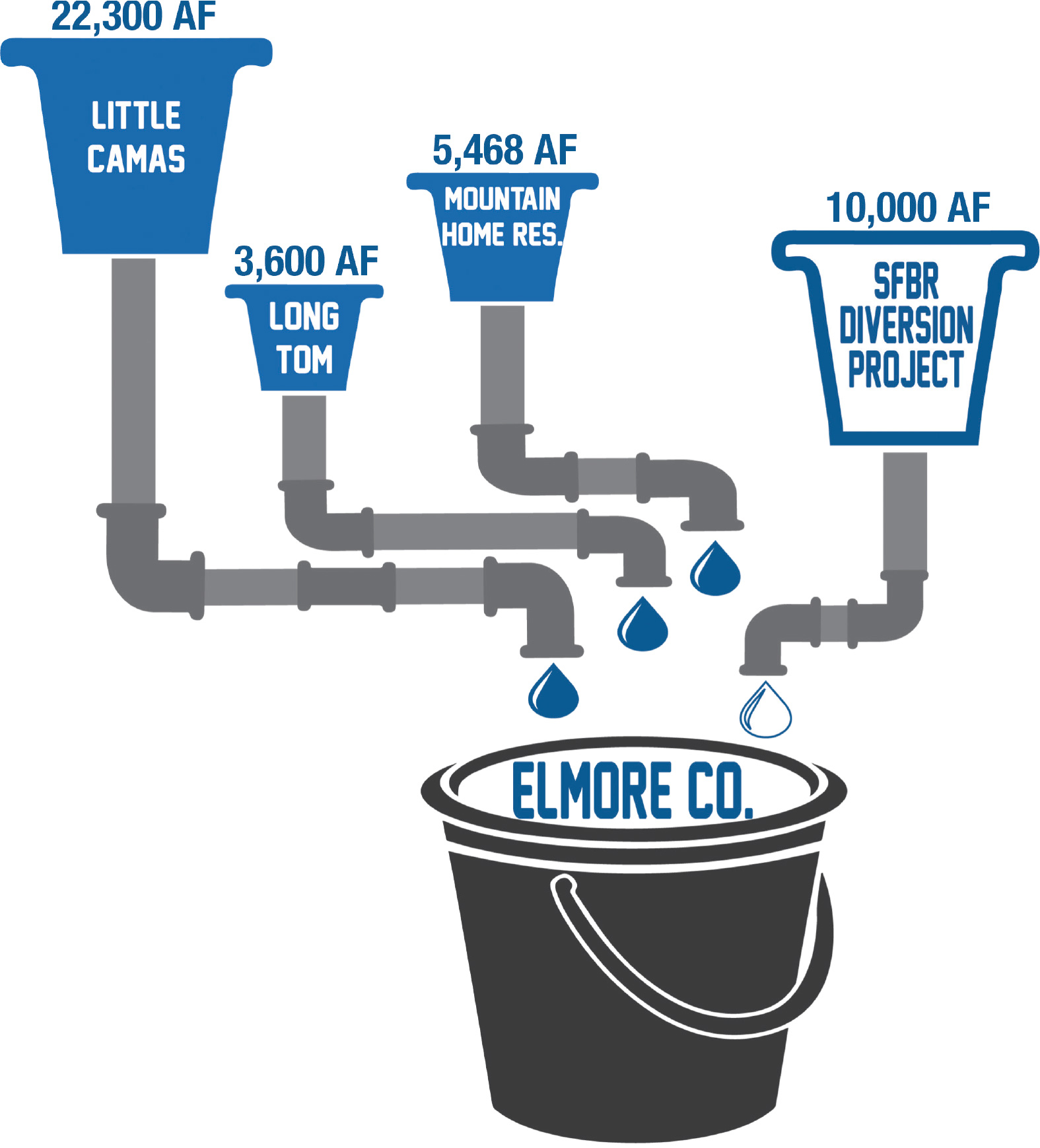
Reservoirs are measured in “acre-feet,” which is equivalent to a 1-foot depth of water covering a single acre (43,560 square feet). A single acre-foot of water is equivalent to 325,851 gallons of water. The three largest reservoirs in southwestern Idaho, regarding total water capacity, are Anderson Ranch (413,100 acre feet), Arrowrock (272,200 acre feet) and Lucky Peak (264,400 acre feet). Within Elmore County, the Mountain Home Irrigation District (MHID) operates three reservoirs: Little Camas (22,300 acre feet), Long Tom (3,600 acre feet) and Mountain Home (5,468 acre feet). To put it simply and give scale of capacity, Anderson Ranch reservoir is:
413,100 acre feet x 325,851 gallons per acre foot = 134,609,048,100 gallons of water
That number (134.6 billion) gallons of water is a number that is incomprehensible to the average human mind; it’s truly an astonishing amount of water used for a variety of needs for our communities.
The majority of water resources in southwestern Idaho reside directly or partially within Elmore County boundaries, though all of it eventually travels downstream in some fashion, whether through surface water or aquifers. Reservoirs are a key component to retaining and efficiently using water wisely over a large area. They are put in place to subvert potential flood events, capture precipitation and capture snowmelt from the mountains of Idaho. Water is then released to provide supply to crops, cities, industry, fisheries and oftentimes hydroelectrical purposes through giant turbines (energy creation); hence, it can be managed in a proper judicious way for the needs of the entirety of southwestern Idaho.
The aquifer
The Mountain Home Plateau Aquifer is a portion of the Western Snake River Plain Aquifer made up of basaltic rock and extends westward to include unconsolidated rock deposits encompassing Ada, Canyon and Owyhee counties, and extending into Payette and Gem counties and even eastern Oregon. Aquifers are underground water systems where water is stored within pores and fractures of sediments and impermeable bedrock. The function of aquifers is quite unique; as water infiltrates downward throughout the soil profile, the soil particles, sand/silt/clay (and chemistry) remove and filter the water. Clay particles are best known for their filtering properties, but even sand and silt play a role in this process.
Aquifers hold vast amounts of clean water, which is accessed through wells. Well depths depend upon the specific area and, on the Mountain Home Plateau Aquifer, might range from just a few tens of feet to over a thousand feet below the soil surface. The water table is found within 20 feet of the soil surface in some areas and at more than 500 feet below in other areas. Wells are typically drilled to a sufficient depth below the water table to allow for pumping drawdown (e.g., the lowering of the water level in the well bore, which induces water to flow to the well). When a well is pumped, the water level is lowered both inside the well and within the adjacent aquifer (i.e., the cone of depression). When pumping stops, the water level rebounds. The cumulative effect of pumping many wells can be seasonal fluctuations of the water table, but if groundwater pumping exceeds the rate of recharge to an aquifer, water levels will not fully rebound each year but instead begin to decline over time.
Within Idaho, the Idaho Department of Water Resources (IDWR) is charged with management of water rights, well information, streams, dams and flood mitigation throughout the entire state. IDWR has been tracking groundwater levels in the Mountain Home Plateau Aquifer since the late 1970s, monitoring wells collaboratively with the U.S. Geological Survey (USGS). Within Elmore County, several prominent wells have been consistently declining between 1.5 and 3 feet per year, something of significant concern to water managers and users alike. Moreover, within southwest Boise and adjacent areas of Ada County, wells have been going dry, according to local published news articles.
Water projects
Currently, the Elmore County Commissioners and IDWR are pursuing several important and impactful water-related projects to help provide Elmore County and the entirety of southwestern Idaho with water security into the future. Elmore County, in conjunction with IDWR and the City of Mountain Home, have completed the Canyon Creek Recharge Project. The Canyon Creek Recharge Project diverts snowmelt and excess reservoir water supplies to headgates that divert this water into gravel pits, hence recharging the Mountain Home Plateau Aquifer locally and maintaining local groundwater levels.
More recently Governor Little, the State of Idaho Legislature (Joint Finance-Appropriations Committee, JFAC) and Mountain Home Air Force Base (MHAFB) have agreed on the Snake River Water Intake, Pump and Pipeline project near CJ Strike Reservoir (Snake River), building a pump station and a 14-mile water conveyance pipeline up Highway 51 to the MHAFB. This project is estimated to cost up to $30 million. In conjunction, the Air Force will pay for and build a water treatment plant on the base premises, with estimated costs between $33 and $39 million.
Project proposals
IDWR and the Bureau of Reclamation are proposing raising Anderson Ranch Dam a total of 6 feet, as well as improving the turbine hydropower infrastructure. The dam raise would provide an estimated additional capacity of 29,000 acre-feet behind Anderson Ranch Dam, providing some new water availability to downstream users. IDWR has not yet determined where the new water will go. It is anticipated that some of the 29,000 acre-feet will support downstream fish flows and the remainder made available for domestic, commercial, municipal and industrial (DCMI) purposes below Lucky Peak Reservoir. However, Elmore County is actively petitioning the IDWR for 10,000 acre-feet of that space to stay in Elmore County. The Anderson Ranch Dam project is estimated to cost around $90 million, with most of that being state-funded.
In conjunction to this project, Elmore County is also seeking the South Fork Boise River (SFBR) Diversion Project. This project would install a pump station and pipeline from Anderson Ranch Reservoir to Little Camas Reservoir, providing direct and much-needed irrigation water for the MHID and recharge for the Mountain Home Plateau Aquifer. These projects could provide up to 10,000 acre-feet per year of flood flows directly to the MHID system. The SFBR Diversion Project is estimated to cost $30 to $50 million. If the county is successful in obtaining an additional 10,000 acre-feet of the new Anderson Ranch Dam raise storage, the cost of the SFBR Diversion Project could decrease by up to half.
Whichever project you may support or have serious concerns about, it is apparent the future water security of southwestern Idaho depends upon resources and funds for Elmore County. In addition to the continuing aquifer declines, Elmore County is experiencing unparalleled growth currently (3%), along with the entirety of the Treasure Valley. If Elmore County remains at 3% growth, its estimated population by 2065 would be nearly 100,000 people, nearly four times what it currently is. The Treasure Valley population is estimated to reach over 1.5 million people by 2065, and existing water storages (e.g., reservoirs and aquifers) need to be prepared for new water customers, and funding mechanisms should be looking into the future of water security for all Idahoans.


