Over the past several years, my work in agricultural extension has increasingly involved integrating new technology to help producers make better-informed management decisions. One of the most transformative tools I’ve incorporated into my program is the use of drones – unmanned aerial systems (UAS) – to observe, measure and document changes in crop production. The ability to see a field from above has opened a new dimension of understanding, offering a perspective that cannot be matched from ground level or even from the seat of a swather. This shift in perspective has not only enhanced the way I deliver extension education but also changed how consulting agricultural professionals interact with producers to optimize crop performance.

From ground to sky: Why perspective matters
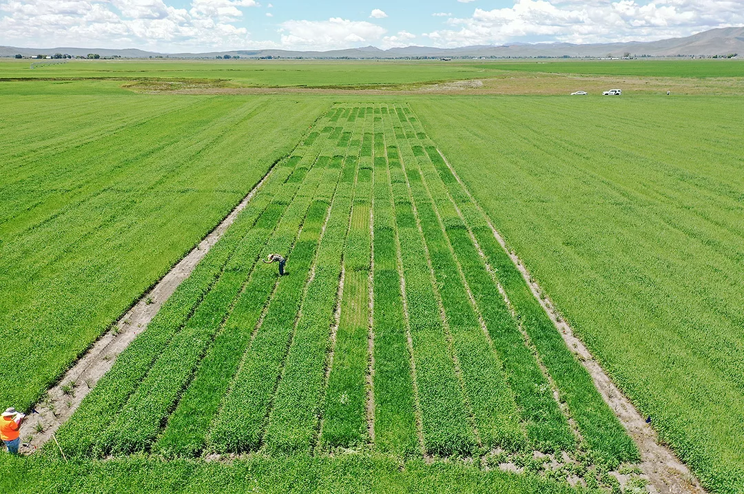
Forages form the foundation of many livestock operations in Idaho and across the Intermountain West. As an extension professional working closely with producers, I'm often engaged in diagnosing issues of crop performance, stand health or uneven productivity. Traditionally, these evaluations were done by walking the field, digging plants and making visual assessments. While those methods remain valuable, they are inherently limited by the narrow field of view from an eye-level perspective. Even the most experienced agronomist can miss subtle patterns that only become apparent from above.
That is where drones have proven invaluable. By providing an aerial vantage point, I can now document entire fields in a single flight, revealing spatial variations in plant vigor, soil moisture or pest impact that are otherwise difficult to detect. What once might have taken hours of scouting can now be captured in a set of high-resolution images in minutes. More importantly, those images serve as digital evidence – objective records that can be analyzed, shared and discussed collaboratively among producers and agronomists.
Case example: Identifying low productivity zones
One of the earliest and most illustrative examples of the power of drone imagery came from a producer who requested my assistance to understand areas of low productivity in his field. From ground level, he could tell that some patches were not yielding as well as others, but he couldn’t pinpoint the pattern or extent of the issue. Using a drone flight over the field, I captured a series of images to create an aerial view of the entire field with consistent scale and resolution.
The resulting image told a story that the naked eye could not. Variations in green cover were clearly visible, showing distinct zones of higher and lower vigor. When overlaid with yield data and soil maps, the producer and his consulting agronomist could start to identify possible causes – differences in soil texture, irrigation uniformity or nutrient distribution. What had been a generalized perception of “poor spots” became a precise conversation about targeted management zones.
This type of imagery provides not just evidence but also a shared reference point. In a discussion between producer and consultant, a picture from above eliminates ambiguity. Instead of describing an area as “that corner by the ditch,” both parties can point to the same image, quantify the size of the affected zone and discuss specific corrective actions such as adjusting irrigation timing, applying variable-rate fertilizer or reseeding select areas. The result is a more data-informed and efficient decision-making process.
Using drone imagery for crop loss documentation
Another area where drones have proven to be exceptionally useful is in documenting crop loss. Producers occasionally face circumstances where they must provide evidence of loss due to weather or pests, often for insurance or disaster assistance purposes. In such cases, aerial imagery becomes a reliable and objective means of documentation.
I have assisted producers by conducting drone flights to document damage. The images clearly delineate the boundaries of affected areas, allowing producers to quantify the percentage of crop loss by improving ground truth estimates. Moreover, the digital records become part of the producer’s file, providing permanent, time-stamped evidence that can support claims or management decisions. I estimate this capability of a drone to be continuous in crop production and evolve as technology advances.

Aerial imagery reveals spatial variability in corn canopy density – supporting targeted management decisions for irrigation, fertility and stand uniformity. Image by Grant Loomis.
Evolving technology and regulatory challenges
As with any emerging tool, the integration of drones into agricultural operations comes with its own set of complexities – particularly in terms of regulations and technology standards. Working under the University of Idaho Extension system, I'm required to adhere to federal and institutional policies governing drone operation. These policies ensure that all flights comply with Federal Aviation Administration (FAA) Part 107 regulations and that the drones used meet certain security and data privacy standards.
Recently, the landscape of drone manufacturing has changed considerably. Some manufacturers, due to federal security restrictions, have been placed on a list of prohibited vendors, meaning their drones are no longer permissible for use in university or federally funded operations. This change required me to replace my previous drone, which had performed admirably, with a new model that meets approved criteria.
While the new drone represents a significant financial investment, it underscores an important lesson for anyone considering the use of this technology: always research the regulations and compliance requirements before purchasing or operating a drone. What may seem like a simple off-the-shelf purchase can quickly become a compliance issue if the equipment does not meet institutional or federal standards. Staying informed about these evolving regulations is essential for anyone in agricultural consulting, extension or production agriculture who uses drones as part of their professional practice.
Becoming a licensed operator
For those interested in incorporating drones into their work, I strongly recommend becoming a licensed drone operator under the FAA’s Part 107 certification. The licensing process ensures that operators understand airspace classifications, weather considerations, flight safety and legal responsibilities. More than just a regulatory formality, this training enhances safety and professionalism in the field.
In agricultural settings, flights often occur near infrastructure, livestock and occasionally in proximity to rural airstrips or manned aircraft activity. Operating legally and confidently is essential not only for compliance but for ensuring that the technology remains a positive and trusted addition to agricultural systems. In my own experience, being licensed provides peace of mind and adds credibility when working with producers, university administration and regulatory partners.
The future of drones in forage production and extension
The application of drones in agriculture continues to evolve rapidly. Beyond simple imaging, new sensors and software are enabling deeper insights into crop health and environmental conditions. Multispectral and thermal cameras can detect variations in plant chlorophyll or moisture stress before visible symptoms appear. Image analysis software can estimate biomass, identify weed encroachment or detect pest damage automatically. As these technologies become more accessible, extension professionals will have increasingly powerful tools for demonstrating best practices and guiding management decisions.
However, technology is only as valuable as the people who interpret and apply it. The real strength of drone imagery lies in its ability to foster discussion, learning and collaboration among producers, consultants and educators. Aerial data does not replace field scouting or local knowledge – it complements them. By combining drone imagery with on-the-ground expertise, agricultural professionals can move toward more precise, efficient and sustainable production systems.
Conclusion
Drones have changed the way I approach my work in extension. What began as a curiosity has become an essential part of my toolkit for engaging producers and promoting data-driven decision-making. The perspective from above provides a new way to visualize the complexity of forage systems, turning observations into actionable insights.
As agricultural professionals continue to navigate the balance between innovation and regulation, drones represent both opportunity and responsibility. They offer powerful capabilities but also demand that operators remain informed, compliant and conscientious. For those willing to invest in learning and operating drones properly, the return in improved understanding, efficiency and communication is immense.
In the end, drones remind us that sometimes the best way to see what’s happening on the ground is to step back – and look from above.