Determining optimum timing for harvest – to find the best balance between high yield and high quality – has always been a challenge, especially with alfalfa crops, while factoring in the best timing for weather.

Harvester-mounted yield monitor systems for grain crops were developed in the early 1990s, with the advent of sensors and information technologies. A yield monitor system utilizes three sensors attached to the harvester for measuring mass flow, moisture and location using a GPS unit.
The first yield monitor systems were installed on combines to harvest crops like corn, wheat and soybeans. Sensors suitable to determine forage yield were brought to the market later. For crops like alfalfa and grass, sensors are located on the harvester and not the mower. Today, yield estimation can be done remotely using drones and satellites (remote sensing).
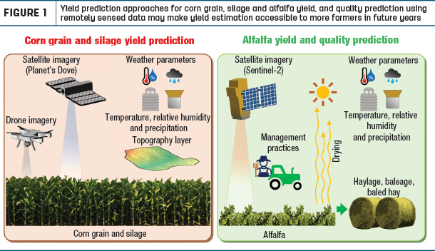
Work is currently underway at Cornell University to evaluate accuracy of various approaches to estimate yield across multiple years and multiple fields and regions, for grain and silage corn, and to derive yield-stability-based management zones from satellite imagery.
A paper entitled “Remote Sensing to Estimate Yield of Field Crops” was recently published by those researchers (Sunoj Shajahan, a postdoctoral researcher; and Quirine Ketterings, professor with the Nutrient Management Spear Program in the department of animal science at Cornell University; along with Jerome Cherney, professor; and Louis Longchamps, assistant professor with the soil and crop sciences section of the School of Integrative Plant Science at Cornell University).
With perennial forage crops like alfalfa, the primary interest in remote sensing relates to estimation of both yield and forage quality, with the goal of predicting optimum harvest date. Previous research found that data gathered with a spectrometer (that measures reflectance over a specific portion of the light spectrum) positioned above an alfalfa canopy can estimate forage quality and yield reasonably well.
Sensors attached to drones have been used to capture crop responses by scanning above the canopy. These sensors capture color and infrared signals (basically a grid of numbers) which are mathematically manipulated to calculate vegetation indices.
Vegetation indices are used as an approximate measure for crop yield, crop stress, nutrient deficiencies, etc. Earlier work, on a smaller scale, showed that normalized difference vegetation index derived from drone images can be a good representation to estimate yield. Current work at Cornell is focused on including weather and topographic information for developing models to estimate corn grain and silage yield across multiple fields. Utilizing satellite imagery has been beneficial in this endeavor. Unlike drones, satellites do not need pilots to capture images.
Similar work with alfalfa is being done by Zhou Zhang (assistant professor, University of Wisconsin – Madison). She and her colleagues have published a paper about alfalfa yield prediction using drone imagery. “We’ve also published a paper about alfalfa quality prediction using drone-based hyperspectral imagery and machine learning. Hyperspectral data is different from traditional digital images we are all familiar with. Those digital images contain only the three-color band (red, green and blue), while the hyperspectral data can provide more color information – even beyond what our human eyes can see,” she explains.
“It can help us monitor crop growth – any kind of crop. We apply this technology to collect images over the alfalfa crop and extract the information from this large-scale data and create machine learning models to estimate alfalfa yield and quality. The images derived regarding yield and quality are comparable to what we can derive in a traditional field sampling approach.”
For alfalfa, this is very important because we don’t have a good yield monitor like we do for corn and soybeans, where we can easily collect yield maps. “For alfalfa, if we want yield maps to understand the variability within a field, we can use drone technology and imaging to do this,” she says.
“This is more important with alfalfa than for corn and soybeans because it can save a lot of labor and costs, to provide the necessary yield and quality maps. We are also working on some satellite-derived remote sensing. The drone can provide higher-resolution data because the drone is closer to earth than the satellite, but we need to send some people into the field to operate the drone and to collect the image data. For the satellite imaging, we can gain access to the publicly available data online. This is something we are looking at right now,” says Zhang.
It is crucial to determine optimum harvest timing for alfalfa because as the yield goes up, the quality goes down. “We need to try to find the best balance, so we keep monitoring the crop using the satellite images and find the cutoff point in that window for optimum time of harvest. This is what we are currently working on,” she says.
Remotely sensed data will become even more useful for farmers over time as we learn to estimate and predict yield and forage quality. This USDA project was initiated in 2021 by the University of Wisconsin, Purdue University and Cornell University. A web-based program will be developed to provide timely estimates of alfalfa yield and quality at the field scale for optimizing harvest scheduling. Data collected by Sentinel-1 (radar sensor) and Sentinel-2 (optical sensor) satellites will be combined with CubeSat data, along with weather data, to generate models for predicting the best harvest date.
Satellite imagery has improved. Before 2015, there were satellites that provided images at five- to 15-day intervals. In 2015, satellites were launched that provide images daily. Image resolution (the ground distance that each image pixel covers) of earlier satellites was not as high as what we have today. Satellite data may now allow an estimate of the yield and quality of alfalfa with precision and accuracy similar to that of a field spectrometer.
“We are trying to provide alfalfa growers with economically optimum harvesting recommendations. The platform will include explicit consideration of alfalfa growth and quality changes, drying rates and weather-related risks incurred during harvest. The developed online platform will serve as a one-stop portal to provide easy-to-use tools to assess different cutting options and develop plans that best satisfy each grower’s risk preferences. This platform is called Alfadvisor,” Zhang says.