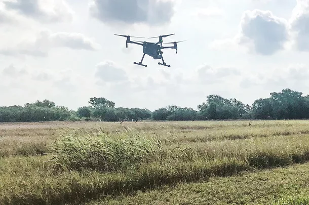
Pasture health and growth is crucial to raising livestock; every stockman must essentially be a forage producer. Timely rotational grazing and proper stocking rates can optimize production and improve degraded pastureland. One of the most useful tools today in monitoring and mapping pastures is a drone.

Drone technology simplifies these processes by providing an efficient, quick way to map and gather information from selected areas of the farm or ranch. With a complete map containing appropriate data, it’s easier to evaluate options and track any changes over time. A drone’s ease of use allows the operator to collect more data with less labor. Geo-referenced maps can pinpoint heavily grazed areas, patches of invasive weeds, areas that need more grazing, etc.
Jamie Foster – professor of forage agronomy, Texas A&M AgriLife Research – is doing research with drones to provide ways to improve farmers’/ranchers’ estimates of herbage mass in pastures. “We can also look at botanical composition – the types of plants growing in a pasture. Our goal is to be able to more accurately measure forage quantity and quality – what the forage consists of,” she explains. This information can aid pasture management, determine maturity of forage plants and determine when to move the grazing animals.
Landowners need to learn how to operate drones, however, and know what is involved. “Some people have asked if they can sit in their house and fly the drones, but there are regulations and policies regarding drone operation. You must keep a line of sight [be able to always see the drone] when it is operating,” Foster says.
There are also some issues if you are near an airport or flight zones for aircraft. Drones cannot interfere with airplane flight. The Federal Aviation Administration has websites available that give information about rules and regulations regarding drones. There are also rules about flying over other people’s property; their privacy must be respected.
Drone technology has evolved and improved in recent years. “Battery life is much longer, and we can cover more acres. Also, the sensors the drone carries are less expensive and lighter weight, so you can carry more sensors on the drone,” she explains.
One of the challenges with using drones to monitor and check grasslands is that there are usually many acres involved. “We are still limited on battery life. If you were to cover the entire property, it would take multiple flights, or you might just cover a portion to obtain a subsample of a pasture, like we do for soil or forage sampling within a big field,” says Foster.
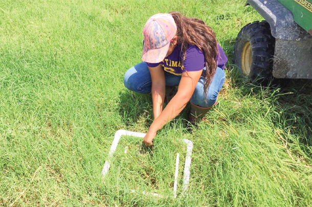 Brittany Garza installs quadrants in a pasture before a drone flight. Photo provided by Jamie Foster.
Use of drones is a technology that some farmers and ranchers are readily embracing, while others are waiting and watching to see if it might eventually be useful in their own operation, and still others are not interested. “This is true with any new practice. There are always innovators and early adopters – the landowners or stockmen who are interested in moving to the next new thing. There are also some who lag behind because they are not interested in change,” she says. They feel that what they are doing still works, and they don’t want to go outside their own area of experience.
“Row-crop farmers are much farther ahead in their use of this tool. There are precision agriculture systems for dropping fertilizer in precise areas, based on soil testing and mapping. We don’t really have this yet for grasslands.” Row crops are managed more intensively and bring greater profit per acre, while grasslands are managed more extensively. But there is opportunity to do more with grassland monitoring and management.
We can more precisely manage any input application. Ranchers can learn from crop farmers’ innovations and experience. The farmer is blazing trails that ranchers can follow. “The ways we use drones applies to grasslands in many cases,” says Foster.
We may not be able to fly and completely map a 3,000-acre pasture, but we can improve sampling approaches to assess pasture productivity and use that information to get better estimates of the amount of forage available for livestock in that pasture.
Dr. Humberto Perotto – associate professor in landscape ecology, Texas A&M – Kingsville, says that in the last couple of years, we’ve learned how to capture imagery and look at species composition and distribution. “We were successful in a pilot study to quantify the amount of crude protein in tanglehead (Heteropogon contortus) based on its spectral signature. This study showed that there are many other things that can be done with drones,” he says.
“It may be a couple more years before some of this becomes a solid technology for ranchers and landowners. Even now, however, your drone can collect photos and send them online to a server; you can get your images ready to prepare maps, such as for controlling brush or patches of invasive weeds or areas where you need to halt erosion.”
You can see something much easier viewing it from above. This enables you to start planning to address small problems before they become big problems.
There are many practical uses for drones, and their cost has come down. “Sophisticated drone technology and high-performance drones six or seven years ago might have cost 100,000 dollars and now [are] more like 25,000 dollars. Multispectral and thermal technology has become more affordable; it used to be 60,000 dollars and now is 8,000 to 10,000 dollars. Regular drones might cost 500 dollars and up, depending on your needs and the accuracy you want,” Perotto explains.
Using drones for pictures and mapping enables you to measure and monitor. You can fly the same area again on a regular basis and see any differences. This enables you to know if you are doing an effective job of pasture management and to see if the pasture is improving or degrading.
“People are already doing this in an informal way, but I haven’t yet seen any research with time series data for monitoring. At the Caesar Kleberg Wildlife Research Institute, we have a student working on what we call spectral signature. We have a multispectral camera looking at species of native bunchgrasses. We want to understand when and where we can differentiate them using remote sensing technology [drones] so we can estimate composition and abundance in the pasture. We can integrate this information with satellite imagery and look at diversity of the pasture.” This is important because multiple species in a pasture is always better than a monoculture – better for ecological processes and function of the pasture and for the animals; their food source is not as limited.
On a small acreage, it might be easy to monitor most things from the ground, but on a large place with many pastures and many cattle, drones can be helpful. “There is free satellite imagery available that people can use. If you have a problem area in a field or pasture, you could start looking at it with more detail. You can fly the drone and have a much better picture of what’s happening there,” says Perotto. Satellite images can be obtained weekly.