Researchers from the USDA’s Agricultural Research Service (ARS) are working on a new way to use satellite imagery for rangeland management – using the grazing patterns to predict cattle weight gain over a period of time.

In December 2021, ARS released a study published in Ecological Applications which was done at the Central Plains Experimental Range, a long-term agroecosystem research network location in eastern Colorado. The team used current satellite images coupled with field observations of over 40 pastures throughout 10 years to make their predictions.
Using satellites to gather forage-related data and make decisions isn’t a new concept, according to Sean Kearney, a post-doctorate research associate who worked on the project. But using it in this application is unique.
“Being able to get more frequent images is something we’ve been incorporating into a lot of our research,” he says. “We had some new estimates of forage conditions from satellites, and we wanted to see if we can apply those to estimating cattle weight gain as well.”
With encouraging results, Kearney and team are optimistic they can use this methodology to provide valuable insights on cattle grazing over a large area in a new, hands-off way – to the benefit of researchers and cattle producers.
Looking to satellites
Monitoring cattle weight gain throughout their grazing season can help reduce waste patterns by analyzing the data. The satellites can capture pasture growth and reduction. This particular study used no GPS collars or tracking for the animals; instead, it was all based on the forage condition, quality and availability as seen from the satellite’s images.
“We were very, very pleased with the results,” reports Kearney.
One of the biggest benefits to this system is the way to track cattle and beef efficiency in real time.
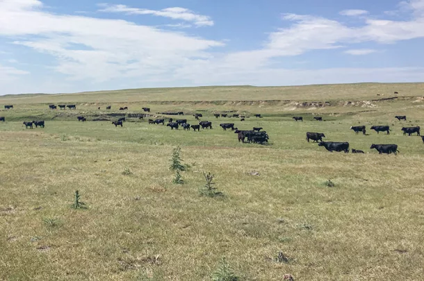
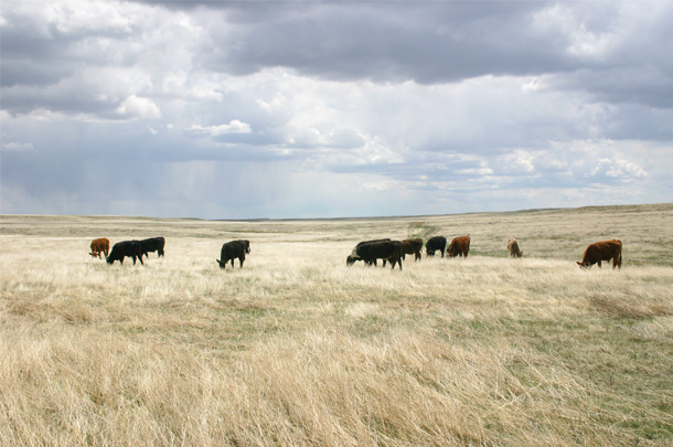
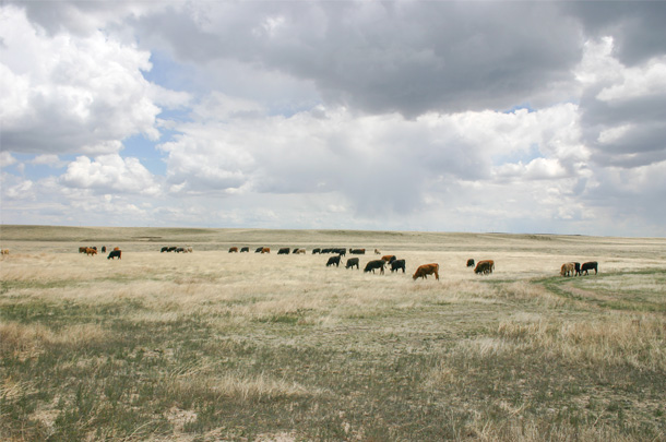 These three images show a progression (top to bottom) from lower-biomass/higher-quality forage to higher-biomass/lower-quality forage. Free-ranging cattle weight gain tended to be lower under conditions on the bottom, when diet quality was low, even if forage biomass remained high. Photos provided by Dr. Edward Raynor, USDA-ARS
“We noticed the gap that not many people are translating [satellite] information into things more relevant to ranchers, like how good-quality the grass is and how much cattle are going to gain,” adds the project’s research ecologist, Lauren Porensky. “We really wanted to try and take this new technology … and turn it into real-time and actionable information for ranchers.”
She says one of the key benefits to satellites, in addition to functioning in real time, is: It eliminates some human errors that come from manual sampling and pasture evaluations. It is also a big timesaver for researchers, ranchers and land managers alike.
“It’s very difficult to get out on the landscape and make some of those real-time assessments and collect any sort of monitoring data to inform our decisions,” says Stephanie Magnuson, a rangeland management specialist with the U.S. Forest Service in Ault, Colorado. “Using a remote sensing tool to cover so many acres at once … there’s a lot of potential in terms of utilization and efficiency.”
A look at the data
An interesting finding Porensky notes from their research was the importance of quality over quantity. Many ranchers in dryland systems, she says, focus on putting cows in pastures with the most biomass.
“But what we found is: Quality can be driving gains so much more than biomass, especially in the late season when grass is dry,” Porensky explains, “and if you find those higher-quality spots, the cattle are going to be able to take advantage of that and convert it into gains.”
 These three images show a progression (top to bottom) from lower-biomass/higher-quality forage to higher-biomass/lower-quality forage. Free-ranging cattle weight gain tended to be lower under conditions on the bottom, when diet quality was low, even if forage biomass remained high. Photos provided by Dr. Edward Raynor, USDA-ARS
Another interesting point of their research was the timing of grazing for forage maximization. Porensky adds that some of their data suggested ranchers may be missing peak grass quality by keeping the herd in a location after forage quality has declined past a certain point.
The cattle themselves also have an influence on how grasses were utilized. Kearney notes there are other studies ongoing to look at whether cattle who were born on the short-grass prairie performed better than steers from tall-grass prairie regions. They are specifically looking at the genetics and environmental impacts that may complement their findings.
“We only have so much data to work with extremely wet or extremely dry years that are within the dataset that we use to develop estimates,” he notes. “That might change the reliability of the model, as does climate change.”
In the future, he anticipates some more unusual weather patterns that might help further develop the system beyond the historical data they used.
Future applications
There is a plethora of applications in which satellite predictions and snapshots can be used for graziers and land managers. And as more time goes on, the more data can be used providing more insight about grasslands and cattle, to the benefit of the environment and more efficient beef production.
As of now, this technology is not accessible to individual ranchers. However, Kearney hopes it could potentially be funded through government programs and made freely accessible for producers.
“I think this is an opportunity to have more information that will allow better decision-making,” shares Porensky, “and maybe allow ranchers to make more money by knowing where good-quality grass is and where the animals are going to gain the most.”
As a rangeland manager, Magnuson is especially hopeful satellite technology will be developed and implemented across even larger landscapes to make faster decisions compared to other technologies on the market.
“I think the key to making it successful … is making it accessible,” she says. “The more user-friendly it is, the easier it is to interpret and access. I think that will promote [this system] across the industry, and I’m really hopeful for that adoption quickly.”
Jaclyn Krymowski is a freelancer based in Ohio.